|
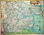
Norden's Map of Essex, 1594 Norden's Essex is colourful and remarkable.11 The map shows clearly how the 'Ocean windeth itself' into the land and the fanciful sketches in the sea of a monster pursuing fish are delightful to the eye.12 The river boundaries are clear: the Stour in the north; the Lea in the west; and the 'Tames' [sic] in the south. The dominance of the country house is evidenced in the parkland and fences which dot the map. The compass rose is interestingly divided into two on the edges of the sheet. The surveyor or cartographer's skill is not yet machine-like and retains its human and fallible qualities. Latchingdon has a line or 'arrow' connecting it to its site, as if there was no room left for the full horizontal label where it should be. Young folk, no less than our selves, deserve to be reminded that map-making, like spelling, is a perfectible art. The borders on this map have a scale graduated in two-mile divisions. There are numbers along the top and bottom and letters at the sides to help locate places listed in an accompanying Description of Essex. The map itself is on the scale of 2 1/2 cms. to 1 mile. Look out for different symbols representing large towns, market towns, parishes, a few hamlets, large, medium and small mansions, a few castles, (Hedingham and Hadleigh), forts or beacons, (Laindon and Candewdon), former religious houses and some bridges and water-mills. Walton had then a tower. The road pattern varies on the different versions of Norden's Map, though only a short space of time separates their depiction.13 This variation suggests caution in accepting the evidence of his map for contemporary roads. Note, however, how the road from Chelmsford to Braintree diverges to include Leighs [Leez] Priory and that the way from Rayleigh to Maldon went directly, probably via Hullbridge, which seems then to have been a broken down bridge, (it has never been rebuilt). There are very few slips with regard to parishes mentioned. The (former) royal palaces are shown: Havering, Wanstead, Copt Hall, Woodham Walter and New Hall. 'Queen Elizabeth's Hunting Lodge' so familiar to visitors of Epping Forest is here called 'ye king's place'.
|
||||
 |
|
|
|