
|
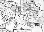
Map of Great Henny showing remnants of field strips, D/DU 332/9a Much of Tudor Essex had been enclosed for centuries, but there were traces of ancient open-field systems, as here in the north-east of the county close to the Suffolk border. On the centre-left of the map and marked by the arrow, Robert Wright had four contiguous strips. These do not have fences or hedges, but, as the map-maker explains, have 'pricked lines' which he tells us signify 'baulkes'. Across the road and among the lower-lying meadows, Isaac Wyncoll was not so lucky and his strips or 'doles' were separated from each other.
|
||||
 |
|
|
|