
|
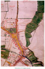
Walker Map of Chelmsford, 1591 John Walker senior, (born .1550) and John Walker junior, (b.1577) were outstanding map-makers who worked and lived in Essex around the end of the sixteenth century. They were commissioned by county gentlemen to make maps and to draw up written surveys of their estates. The flowering of their cartographical skills then was no accident. The dissolution of the monasteries and other changes of the period had led to a booming land market in which proud 'new men' were keen to have a tangible representation of their freshly gained substance. The surveying of the Walkers is accurate. Their draughtsmanship and lettering is fine. The use of reds and greens is attractive. Like most map-makers they enhanced their work with small drawings of churches, mansions, houses, cottages, windmills, trees and farm buildings. Unlike many map-makers, their drawings are not conventional symbols but are passable attempts to render actuality. If a roof was tiled then it is depicted in red; if thatched it was shown in yellow. If a chimney or door-case was off-centre, then so it is on the map. Not a bar, rail or stile it seems is out of place. The parish church of St.Mary is visible towards the top and north of this Elizabethan town of Chelmsford. There are thatched and tiled barns in 'barne Crofte abutti.
|
||||
 |
|
|
|